Warm Winter 2026: What It Means Offshore

In short
Unusually warm winter ahead: Temperatures are very likely to exceed average across most of Australia, with a strong chance of landing in the top 20% of all records.
El Niño building rapidly: The Pacific is warming at near-record pace, with more than 1°C of warming since January representing the fastest La Niña to El Niño transition since 1976.
What to watch
July is when the dry signal emerges for southern and eastern regions, so June represents your best planning window for winter deep-sea trips before conditions lock in.
The Bureau has spoken, and its June to August 2026 seasonal outlook released today paints a picture that should have offshore anglers paying close attention.
Warmer than usual is the headline, with winter temperatures very likely to track above average and a strong probability they will fall in the top 20% of all recorded winters.
For those who fish, this is not just a curiosity for the evening news but a genuine shift in how the next three months will play out on the water.

The dry signal timeline
June looks unremarkable from a rainfall perspective, with BOM senior climatologist Caitlin Minney noting there is no strong signal for the first month of winter.
July changes everything, and this is where planning becomes critical for anyone targeting southern and eastern waters.
Minney stated clearly: "For July, that's where we start to see that dry signal emerge across parts of the south and the east, with early indications of a strengthening of that signal into August."
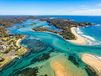
The practical translation: reduced rainfall from July onwards means significantly less runoff entering estuaries along the NSW coast and into Victorian and South Australian systems.
Clearer water follows, and for anglers working estuaries this creates ideal conditions for sight-fishing, soft plastics and surface lure techniques where visual presentation matters.
"Climate models are now strongly aligned, and there is high confidence in the onset of El Niño, followed by further intensification in the months that follow."
That assessment comes from Wilfran Moufouma-Okia, chief of climate prediction at the World Meteorological Organisation, and it carries weight given the global monitoring resources behind it.
NSW and Tassie already parched
Some regions are not waiting for July to experience the dry conditions. NSW and eastern Tasmania already sit in severe to record-low rainfall deficiencies.
Year-to-date totals in these catchments are tracking at historic lows, and the estuaries reflect this with exceptionally clear water that has been evident for months.
Fish behaviour shifts when water clarity increases dramatically, and anyone who has worked these systems recently knows the challenge of spookier fish requiring lighter leaders and more subtle presentations.
Dropping to 6lb fluorocarbon in systems where you would normally run 10lb or 12lb is becoming standard practice for bream and flathead anglers across the NSW south coast.
The upside is visibility, with sight-fishing opportunities for species like mulloway on the flats that simply do not exist when normal winter runoff muddies the water column.
El Niño: the offshore wildcard
The Pacific Ocean is warming at a rate that has climate scientists reaching for the record books and recalibrating their models.
More than 1°C of warming since January represents the fastest transition from La Niña to El Niño conditions since 1976, and the NIÑO3.4 index currently sits at positive 0.23°C.
BOM's threshold for declaring an El Niño event is positive 0.8°C, and current trajectories suggest this could be reached within weeks rather than months.
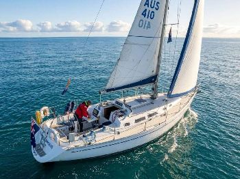
For offshore planning, a developing El Niño typically delivers more persistent high-pressure systems across southern Australia. This translates directly to more settled weather windows.
Check the wind forecast models through June and you should see this pattern beginning to establish, with fewer of the rapid frontal passages that shut down offshore access during typical winters.
Coral Sea operators in particular should note that El Niño historically suppresses tropical cyclone formation, especially for Queensland waters.
Fewer shutdown events during the late season and into the transition months means more reliable scheduling for charter operations and private trips targeting the outer reef systems.

Pelagic patterns shifting south
Warmer winter air temperatures correlate directly with elevated sea surface temperatures, and this has implications for pelagic species distribution that savvy anglers can exploit.
Spanish mackerel, yellowfin tuna and mahi-mahi are all likely to remain in their southern range longer than usual this winter as water temperatures stay elevated.
The Bermagui to Eden stretch could see extended action on species that would normally have pushed north by mid-winter, and similar patterns should emerge along the South Australian gulfs.
Warmer water also means a slower metabolism shift for tropical species, with the usual winter shutdown in feeding activity likely to be less pronounced than in cooler years.
Kingfish behaviour in particular responds to these temperature variations, with fish remaining more active and aggressive when water temps stay above the threshold where metabolism drops significantly.
Snapper patterns will also be worth monitoring, as the spawning aggregation timing and location can shift when winter temperatures track above average.
South-west WA: a different story
Below-average rainfall is forecast for south-west Western Australia, but this is driven by the long-term climate change trend rather than the developing El Niño.
The distinction matters because WA's south-west has been on a drying trajectory for decades, and this winter continues that pattern independent of Pacific Ocean cycles.
For WA anglers, the practical effect is similar to the east coast with reduced runoff into estuaries like the Swan, Blackwood and the south coast inlet systems.
The IOD question mark
One variable remains uncertain: the Indian Ocean Dipole, which currently sits in neutral territory.
Some international models are forecasting a positive IOD to develop, which would compound the drying effect across southern Australia if it eventuates.
According to Minney: "It is still too soon to tell what's going to happen."
A positive IOD combined with El Niño would reinforce the dry pattern and potentially extend the settled offshore windows even further into spring.
The Bureau is watching closely. Minney said they are keeping in mind the potential for further increases in rainfall deficiencies and carefully monitoring affected regions.
Your June planning window
The message is clear: June represents the best window for locking in winter deep-sea trips before the dry signal establishes and patterns become more predictable.
Weather windows in June will still show typical winter variability, but from July onwards expect the high-pressure dominance to become more consistent.
For those targeting marlin on the NSW and Queensland shelf, the combination of warmer water and settled weather could extend the season beyond typical cutoff dates.
Estuary anglers should plan for progressively clearer water from July, adjusting tackle and techniques accordingly as the dry signal strengthens into August.
Charter bookings for the Bermagui canyon typically fill by mid-June, so lock in dates now if you want a shot at late-season blues.
Frequently asked questions
Will El Niño definitely be declared this winter? The NIÑO3.4 index is currently at positive 0.23°C and rising rapidly, with BOM's declaration threshold of positive 0.8°C potentially being reached within weeks based on current warming rates.
How will warmer temperatures affect winter fishing? Elevated sea surface temperatures typically keep pelagic species like Spanish mackerel, yellowfin and mahi-mahi in their southern range longer, while reducing the usual winter metabolism slowdown in tropical species.
What does the dry signal mean for estuary fishing? Reduced rainfall from July onwards means less runoff and clearer water in estuaries, creating better conditions for sight-fishing and lure techniques but requiring lighter leaders for increasingly spooky fish.
Will there be fewer cyclones affecting Queensland? El Niño historically suppresses tropical cyclone formation in Australian waters, particularly for Queensland, meaning fewer weather-related shutdowns for offshore operations in the Coral Sea region.