SE Cold Front: Alpine Snow, 100 km/h Gusts
Quick Summary
A Severe Weather Warning for Victoria's eastern ranges is active — damaging northwesterly winds averaging 60–70 km/h with gusts to 100 km/h are hitting Falls Creek, Mt Hotham and Mt Buller through Thursday afternoon.
Alpine snow is falling above 1,400 metres and southerly swells of 2–3 metres are building on NSW and Victorian coasts in the wake of the front.
What to watch
Winds ease below warning thresholds late Thursday afternoon or evening, but coastal bar crossings remain hazardous into Friday morning.

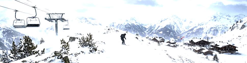
Photo by Matt Palmer on Unsplash
A cold front that crossed Victoria overnight Wednesday has triggered a Severe Weather Warning for the eastern ranges, with the Bureau of Meteorology warning of damaging northwesterly winds averaging 60 to 70 km/h and gusts reaching around 100 km/h above 1,400 metres at Falls Creek, Mt Hotham and Mt Buller. Alpine snow is falling as the front tracks east, and southerly swells are already building on the NSW and Victorian coasts.
The snow is real, and it is stacking up early. Higgins Storm Chasing confirmed snow falling at Mt Hotham on 27 March 2026 — the resort's first of the year, ten weeks before the planned 6 June opening day. A subsequent system on 10–11 April added around 1 cm at mid-mountain level, according to automated station data. Thursday's front is the third significant cold-season snow event since late March. A fourth system is forecast to move across the southeast later this weekend.
The large-scale driver is classic autumn. As summer ends, the temperature contrast between the tropics and Antarctica widens, and the Southern Ocean westerly belt tightens. Cold fronts embedded in the westerlies become deeper and faster-moving through April and May. Each follows the same pattern: northwesterly prefrontal winds ramp up ahead of the trough, the cold change pushes through, and a southwesterly airstream draws cold maritime air across the Alps and the southern coast behind it. Three fronts through April before the ski resorts even open is not unusual, but this year's run has been more potent than average.
Early season comparison — three events before May
Three snowfall events before the end of April is above average for the Victorian Alps. The 2026 winter forecast from SnowBrains identified Mt Hotham and the highest terrain at Thredbo and Charlotte Pass as the areas most likely to outperform on natural snowfall this season. Thursday's event is consistent with that outlook. Early-season snowpack is patchy — wind redistribution creates deep drifts on lee slopes alongside bare patches on the same aspect — but the base is there.
The warning window is short. Winds are expected to ease and tend westerly following the frontal passage, dropping below Severe Weather Warning thresholds by late Thursday afternoon or evening in Victoria. Snow accumulation above 1,400 m will continue until the cold change works through, then taper off as the southwesterly airstream brings drier conditions off Bass Strait.
What this means on the water
The coastal picture is the more immediate concern. The coastal waters forecast flagged a cold front crossing the coastal waters this week, bringing fresh to strong southerly winds in its wake. Southerly swells of 2 to 3 metres were forecast for the Sydney coastal zone, easing to 1.5 to 2 metres through the evening. Conditions are hazardous for bar crossings by boat and for rock fishing on exposed southern and eastern headlands.
The prefrontal northwest is the trap. The northwesterly wind build ahead of a front generates a short-period, wind-driven chop that stacks up against the prevailing ocean swell. On north-facing bays and exposed anchorages — Westernport, Wilsons Prom, Cape Conran — the NW sea can reach confused, breaking conditions quickly and well before the front itself arrives. Fishers who left port in a calm morning are advised to monitor the front timing, keep an eye on the barometer, and ensure they have sea room before the change hits.
Bar crossings are where things go wrong. The post-frontal southwesterly swell of 2–3 metres combined with wind-waves creates breaking bar conditions at many Victorian and southern NSW estuary mouths. Lakes Entrance, Mallacoota, Bermagui and similar south-facing entrances will be hazardous through Thursday afternoon and evening. If you can see white water on the bar, stay inside.
The post-front fishing window can be excellent. The cold water injection from a Southern Ocean front typically drives bait tight to structure and concentrates pelagics like bonito and tuna against the temperature break. Snapper and other bottom species in deeper offshore grounds often feed well in the 24–48 hours after a front, once sea states settle below 1.5 m. The window here opens Friday afternoon and sharpens through Saturday.
NSW coast — swell the main concern
For NSW boaters, the southerly swell running at 2–3 m creates difficult conditions on exposed headlands and open-ocean passages north of Sydney Heads. Pittwater, Broken Bay and the Hawkesbury approaches will see heavy southerly sets on exposed northern-facing beaches and reefs. Rock fishing on the southern and eastern exposures between Botany Bay and Jervis Bay is off the table through Thursday afternoon and into Friday morning.
Saturday shapes up as the better window. After the southwest change works through and the swell period lengthens to the 12–14 second range typical of Southern Ocean groundswell, conditions on the NSW south coast and northern Victorian coast usually organise and become more manageable. Saturday is shaping up as the pick day for offshore passage-making and trailer-boat launching at south-coast ramps, subject to the next front's timing.
Watching the next system
The third cold front this month is already in the pipeline. A further system is expected to cross SE Australia over the weekend, bringing another round of alpine snow and coastal swell. April's pattern of back-to-back fronts is in full swing. For the Seabreeze audience, that means planning around front timing rather than hoping for flat conditions — the briefing tool will be updating as each system develops.
Track Seabreeze Victoria warnings and NSW warnings for the latest alerts as the pattern continues.
FAQ
Is it safe to go boating in Victoria or southern NSW today (Thursday 16 April)?
Not on exposed coastal waters. The Severe Weather Warning for Victoria's ranges and the forecast southerly swell of 2–3 m on NSW coastal waters make Thursday unsuitable for trailer-boat launching on exposed south-facing ramps or open-water passage-making. Sheltered bay and estuary fishing is lower risk, but watch bar conditions at any estuary entrance carefully.
How much snow is expected above 1,400 m at the Victorian resorts?
The warning focuses on wind impacts rather than snow totals. Snow is confirmed falling above 1,400 m, adding to the ~1 cm recorded at Mt Hotham mid-mountain on 10–11 April. The coming weekend system may add a further round of accumulation.
When will conditions improve?
Warning-level winds are expected to ease by late Thursday afternoon or evening. Coastal swell eases from 2–3 m to 1.5–2 m through Thursday evening. The post-frontal SW airstream persists into Friday before weakening.
Is this affecting Queensland or Western Australia?
No. This system is tracking east across the SE Australian coast and is a Victoria and southern NSW event. No Severe Weather Warnings for this front are current in Queensland or WA.
What does this mean for the 2026 ski season?
Three snowfall events before the end of April is a promising start. Victorian resorts plan a 6 June 2026 opening. Early snowpack does not guarantee a strong overall season, but consecutive April fronts ahead of the main May snowfall window are a good sign for natural snow depth by opening day.