North Qld's Brutal Wet Season Still Active
In short
Tropical Low 29U crossed the Queensland coast near Tully and Innisfail in early March 2026, triggering a cyclone watch for the Wet Tropics from Cooktown to Lucinda and delivering catastrophic flooding to the Burnett River catchment at Bundaberg — one of nine tropical systems to form in the Australian region since November 2025.
The 2025–26 season has already matched its long-term full-season average in storm count, with more than six weeks still remaining before the official close on 30 April.
What's next
The Madden-Julian Oscillation remains positioned to support further tropical development across northern Australia through late March — conditions that have driven the relentless activity of the past three months are not gone yet.
The 2025–26 Australian tropical cyclone season has been punishing. Nine named systems have formed in the Australian region since the season opened in November 2025, a tally that roughly matches the long-term average for an entire season — reached with more than six weeks still to run before the official close on 30 April. The most recent significant event, Tropical Low 29U, crossed the Queensland coast near Tully and Innisfail in early March 2026, triggering a cyclone watch from Cooktown to Lucinda and setting off a flooding sequence that rolled south across the state in the space of a week. As of mid-March, communities from the Wet Tropics to the Wide Bay-Burnett region are still dealing with the aftermath.
When Tropical Low 29U crossed the coast, BOM issued a cyclone watch stretching from Cooktown south to Lucinda — a coastal strip that includes Port Douglas, Cairns, Innisfail, and the Hinchinbrook area. Wind gusts of up to 100 km/h were possible within the watch zone, and the rainfall potential over already-saturated catchments was the more immediate concern. BOM senior meteorologist Angus Hines described conditions the region had been dealing with: "We've seen frequent bouts of wet weather across both the north and interior of Queensland in recent months, and there's a really prolonged, ongoing flood situation across much of the state." That assessment proved accurate — the system's moisture fed rainfall across a broad swathe of central and south-eastern Queensland after crossing the coast, compounding a catchment situation that had been building since December.
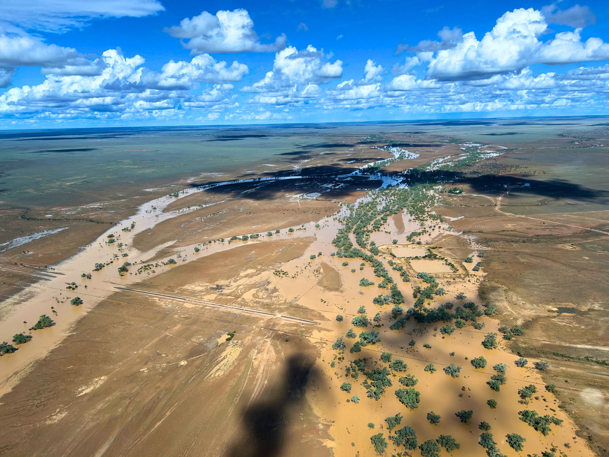
The Burnett River at Bundaberg became the focal point of the southern flooding as runoff from the Wide Bay-Burnett catchment converged on the lower river. The river peaked at approximately 7.4 metres at the Targo Street gauge in early March — not far below the 7.92 metres recorded during the December 2010 event. Evacuation orders were issued for multiple Bundaberg suburbs, 197 people sheltered at the Bundaberg Recreational Precinct evacuation centre, and up to 280 homes and 120 businesses were identified as being at risk of floor-level inundation. Paradise Dam, west of Bundaberg, reached around 200 per cent of storage capacity and began spilling into the river system. The spill from Paradise Dam adds to natural inflow and can sustain elevated river levels for weeks, complicating the recovery timeline for affected properties.
"Nine named systems in one season, the Burnett River within reach of its 2010 flood peak, and the MJO still positioned to keep generating tropical activity across northern Australia — the 2025–26 season is not finished making its mark."
The season's scale becomes clearer when you look at the names. Fina, Bakung, Grant, Hayley, Iggy, Jenna, Koji, Luana, and Mitchell — nine systems since November. For context, the long-term average for the Australian region is around eleven named cyclones per full season, November to April. The season reached nine by early March, well ahead of the pace needed to match or exceed the average. Not all nine affected the coast with significant intensity, but the cumulative effect on catchment saturation across northern and central Queensland has been severe. Each subsequent event has had less dry soil to absorb its rainfall, and the flooding responses have been faster and more extensive as a result.
The Madden-Julian Oscillation is the large-scale driver that meteorologists watch most closely for tropical activity forecasting in the Australian region. When the MJO is in an active phase over the Western Pacific, as it has been through much of the 2025–26 season, it significantly raises the probability of tropical low formation and intensification over the Coral Sea and the Arafura Sea. BOM's tropical climate updates through March indicate the MJO is expected to progress further east and weaken toward the end of the month. Until that happens, the atmospheric conditions that have sustained this season's activity remain in place. Hinchinbrook Mayor Ramon Jayo captured the community attitude in the region accurately when he noted that residents had adopted a watch-and-wait approach to each developing system — not panicked, but no longer surprised.
Communities in recovery mode face the particular challenge of managing ongoing risk while still cleaning up from the last event. For Bundaberg, that means infrastructure assessments, property damage evaluations, and the slow work of removing mud and debris before the next rainfall event arrives. For townships in the Wet Tropics, saturated soils mean that even a moderate rainfall event can produce flash flooding on steep terrain at speeds that give very little warning time. The standard QFES guidance remains directly relevant: never drive through floodwater, regardless of apparent depth. Submerged road damage is invisible from inside a vehicle, and current beneath a still-looking surface can be strong enough to sweep a car off the road.
Cyclone Alfred's impact is a useful reference point for what the season is capable of. Alfred crossed the Queensland coast at Moreton Island in early March 2025 — unusual this far south — and caused an estimated US$1.36 billion in economic losses, knocking out power to around 450,000 homes and businesses at its peak. The 2025–26 season opened with that event fresh in public memory across south-east Queensland, and the activity since November has reinforced the lesson that the late-summer period through April deserves serious attention regardless of where you are on the Queensland coast.
For anyone in areas still affected by flooding, or with boats and property in the Wet Tropics or Wide Bay, staying across the latest warning status is the most practical thing you can do right now. Check the Seabreeze warnings map to see active flood watches, cyclone watches, and severe weather warnings across Queensland — the map updates in real time as BOM issues and cancels warnings across the country. With the season running until 30 April and the MJO still active, the conditions that have made this a standout year for tropical activity haven't fully wound down yet.