Awesome Sunday! Map of approx. path.

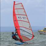
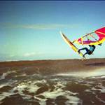
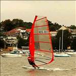
Cleared the SaltPan moorings at 3:30 pm and headed on starboard tack into the gusting nor-noreaster. North of Scotland Is I rotated the centerboard up about 5cm to prevent the 8.5m forcing round-up back-slams. Struggled up to the lee of LongnosePt where I could maximize the downhaul & outhaul, harness lines further back, mast all the way forward, and tacked eastward across towards the AvalonSC. Thinking it's too late to go back and change down to a more stable RSX 8.5 or even the BIC 7m; I tacked north railed-up and started to gain some reasonable momentum and a bit of confidence; at times well overpowered, and occasionally stomping the centerboard right down to maximize pointing through the 10 to 15knot sections. Past the shifty gust and lulls between WestHd and Barrenjoey the breeze moderated to a safe level enough to push on to LionIs. Decided to round it from the western end - but this left me with a hairy downwind sou'easterly broad reach over the very lumpy swells, heading eastward of the Barrenjoey Lighthouse. Pulled away into a dead square run, rocking & rolling down the swells until halfway between Barrenjoey & WestHd; then turned south-east with the gusts onto the plane. Adjacent the red & white channel marker with the strengthening breeze, at full stretch into the back straps and flying confidently back down to Avalon. Gybed well before the Avalon moorings and heading westward past LongnosePt was able to bear away with howling gusts, planing at max Raceboard speed for a good half kilometer, gybing back at the outer edge of MorningBay, into another beautiful fully powered broad reach all the way to be at the outer edge west of SaltPan at 5:05pm. Zero falls, zero sail drops - Stoked!

Scotland Island wind recording 08/01/2017 pittwaterweather.com.au

StokesPt wind recording 08/01/2017
And yes, about time I get a GPS app so I can review the exact route and speeds.


 Depart SaltPan approx 10:45am; return approx 3:15pm
 (Above) Direction & Speed recordings from Stokes Pt (5m above sea level)


 A very enjoyable sail - had it all to myself - not a single other sailing craft out there - just wish I could have had an extra 2 hours.
 and perfect sunshine!