It's not that OpenCPN has a poor quality chart display, after all CPN only displays what chart you put in and if Round Island is not showing on CPN then it probably won't show on any other device with that chart. This now raises the point, if Round Island is not shown then what else on that chart is not shown?
I just pulled up both Navionics and CPN which is loaded with CM93 maps and round island displays on both sets of charts. Ramona can verify this with his CM93charts. Google maps doesn't show Round island either but if you query it with "Round Island WA" it puts a red marker in the spot where it should be.
I had to have a look!! ![]()
I found Round Island on Google maps, OpenCPN & Navionics ChartViewer:


Also found Daw Island in Google Maps also on OpenCPN & Navionics ChartViewer but not named.
My CM93 files are 2011 so not really current!!
Navionics ChartViewer is good for route planning at home, or where-ever, on a big PC & if you have the Navionics app on your phone/tablet with an account it all syncs & your routes are on all devices & connect via wi-fi to your chartplotter.
There is another free Chartplotter app called AvNav which might be worth a look:
www.wellenvogel.net/software/avnav/docs/beschreibung.html?lang=en
Both Round and Middle Islands are shown on my CM93 2015. And just to clarify, if there are discrepancies, it's the chart files (CM93 etc) that are under suspicion, not the chart viewer (OpenCPN).
Daw Island is located at 33.51.201S 124.8.293E.
My requirement for charts is thar they can be regularly updated, which both the OpenCPN charts from O-Charts and Navionics can be done. I'm generally updating every 3 months, or before a long voyage. I also want it to take about 15 minutes, I do not want to be spending hours or days sitting in front of a computer, would be too much like work!
For the people running CM93 files on OpenCPN, when were they last updated and how hard is it to update?
Regarding the difference between OpenCPN and Navionics, its the old adage, you get what you pay for. For $25 a year I am happy to use OpenCPN with charts from O-Charts. However I am also happy to pay more for a more accurate system that is easy to update.
Ilenart
My bad when I said that Round Island is not on Google maps, I wasn't on satellite view. Apologies all.
Select to expand quoteIlenart said..
Daw Island is located at 33.51.201S 124.8.293E.
My requirement for charts is thar they can be regularly updated, which both the OpenCPN charts from O-Charts and Navionics can be done. I'm generally updating every 3 months, or before a long voyage. I also want it to take about 15 minutes, I do not want to be spending hours or days sitting in front of a computer, would be too much like work!
For the people running CM93 files on OpenCPN, when were they last updated and how hard is it to update?
Regarding the difference between OpenCPN and Navionics, its the old adage, you get what you pay for. For $25 a year I am happy to use OpenCPN with charts from O-Charts. However I am also happy to pay more for a more accurate system that is easy to update.
Ilenart
Sounds like an argument for Aus ENC, accurate, updated in real time, and cost more.
Select to expand quotewoko said..Ilenart said..
Daw Island is located at 33.51.201S 124.8.293E.
My requirement for charts is thar they can be regularly updated, which both the OpenCPN charts from O-Charts and Navionics can be done. I'm generally updating every 3 months, or before a long voyage. I also want it to take about 15 minutes, I do not want to be spending hours or days sitting in front of a computer, would be too much like work!
For the people running CM93 files on OpenCPN, when were they last updated and how hard is it to update?
Regarding the difference between OpenCPN and Navionics, its the old adage, you get what you pay for. For $25 a year I am happy to use OpenCPN with charts from O-Charts. However I am also happy to pay more for a more accurate system that is easy to update.
Ilenart
Sounds like an argument for Aus ENC, accurate, updated in real time, and cost more.
Yep, that's what I run.
I will also vote for Open CPN. I have been playing with it on the home computer and found online charts for around the world quite easily. Money saving for sure. But needs a computer to run and which one is most appropriate for onboard use ??
I use one of these driving a 20 inch monitor. On my last yacht I used the same with a 24 inch TV as the monitor.
www.ebay.com.au/itm/203486303773?_trkparms=amclksrc%3DITM%26aid%3D1110006%26algo%3DHOMESPLICE.SIM%26ao%3D1%26asc%3D20201210111314%26meid%3Dde69c1bd5aaf4d7aa1d50519e03572b6%26pid%3D101195%26rk%3D5%26rkt%3D12%26sd%3D194500706792%26itm%3D203486303773%26pmt%3D1%26noa%3D0%26pg%3D2047675%26algv%3DSimplAMLv9PairwiseWebMskuAspectsV202110NoVariantSeed%26brand%3DLenovo&_trksid=p2047675.c101195.m1851&amdata=cksum%3A203486303773de69c1bd5aaf4d7aa1d50519e03572b6%7Cenc%3AAQAGAAABEIIp3bTCXFAKw6S9crk9CpCrrtOgadqFiC10NVPbN0936eprYVB4SXfDa52e1mbPLMqm98ROPboqkLsVGmgpfKsDjmHOdRIj5UTE2pUy0u8nY%252BQuL5bjgUQCnBN%252F0dEV59ZkjYdWOgMDLWNSoxm0BuQ0yvHPcI2ahV2s%252BBZnPL4bqqmxEyvJAhw%252FOvbUzwpLAvW2KmyoG4Md4ejqYJChSBNAdrQuBPcfRynHr8ImMULzjtrlLfVfneaO%252BiJ2N2HenCROwTlDPd%252BWnKdAcy86A0BXzQC1AXGMEnlI2hDebviLIeTB6WEmqNEXgK9CbTwaFecdhhuitgqu%252FlosbSafZ5%252Bq8kvozo8Y5%252Fcm3d7dINGA%7Campid%3APL_CLK%7Cclp%3A2047675
I looked into buying a new chart plotter for the chart table. It ended up about the same price for 2 x IPad pros , i can also use the raymarine app to mirror and use the current cockpit chart plotter from the chart table. Also the advantage of all the marine apps , weather ,tides and crew can take them to there bunks for movies or Netflix as they are always connected to the nighthawk router. A win around Im still thinking. ![]()

I tried Open CPN but had no chart plotter to drive it. So for anyone that might have a trek transponder I added some code and extra part so it can now output the NMEA string it needs so now my Open CPN works :-) The Trek has a good GPS in it. Updates once per second. ![]()
Select to expand quoteJeanReuille said..
I will also vote for Open CPN. I have been playing with it on the home computer and found online charts for around the world quite easily. Money saving for sure. But needs a computer to run and which one is most appropriate for onboard use ??
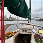
This is my set up this morning. The computer is just above the keyboard. The monitor is set up for portrait, I'm on the East coast and operate along the coast. OpenCPN and the GPS and AIS come from the Standard VHF radio.

I was talking to an old friend about an incident on a boat he was on. It seemed like the crew were using a plotter near the helm and not near the companionway - in the night, they ran aground with some serious results. It was rainy and cold and no-one was near the helm - or the plotter after the boat altered course.
I like the idea of having a plotter of some kind forward of the helm - mine rests on my bridgedeck table, but you can do that on a cat. For monos under the dodger could be a better idea. Then anyone in the cockpit, even those sheltering under the dodger, out of the weather, have to see it when they look up. Popping a plotter out the back means that often it will go un-noticed for maybe too long. Of course, we should also have a screen on inside, but the off watch crew may like it turned down, or the on watch crew can get lazy and leave the nav to someone else - lazy lassez faire.
So a tablet running Navionics or a screen running Open CPN from a Raspberry Pi, somewhere where it is impossible to miss is a great backup. It would have saved my friend a very serious mistake as the huddled crew would not have been able to miss that they were approaching the shore. Redundancy is fab, I like running both OpenCPN and Navionics - they both have their advantages and are so cheap it makes sense to have backups. One worry with Navionics - the charts look very accurate, and they may be, but we should be wary of cutting corners using electronic charts. There is at least one case of a catamaran ending up on a reef because the owners cut close to the shallows and the Navionics charts were off. So, even though Navionics looks like highly precise, they may be innacurate and we have trouble distinguishing the two concepts. Treat Navionics (and any chartplotter) with caution and still use normal seamanship, giving proper room to dangers, using good daylight pilotage in rocks and coral and keeping an eye on the depth sounder and colour and look of the water.
There are dozens of accidents not incidents of people getting into strife using Navionics. Two that I know off within a mile of my homeport. Where one yacht ran aground and another yacht ran up a beach where navionics showed an entrance.
From behind the wheel I can view my plotter screen at the chart table but I also have a Garmin handheld alongside of me. A large screen picture is second only to the mark one eyeball.
Select to expand quoteRamona said..
I use one of these driving a 20 inch monitor. On my last yacht I used the same with a 24 inch TV as the monitor.
www.ebay.com.au/itm/203486303773?_trkparms=amclksrc%3DITM%26aid%3D1110006%26algo%3DHOMESPLICE.SIM%26ao%3D1%26asc%3D20201210111314%26meid%3Dde69c1bd5aaf4d7aa1d50519e03572b6%26pid%3D101195%26rk%3D5%26rkt%3D12%26sd%3D194500706792%26itm%3D203486303773%26pmt%3D1%26noa%3D0%26pg%3D2047675%26algv%3DSimplAMLv9PairwiseWebMskuAspectsV202110NoVariantSeed%26brand%3DLenovo&_trksid=p2047675.c101195.m1851&amdata=cksum%3A203486303773de69c1bd5aaf4d7aa1d50519e03572b6%7Cenc%3AAQAGAAABEIIp3bTCXFAKw6S9crk9CpCrrtOgadqFiC10NVPbN0936eprYVB4SXfDa52e1mbPLMqm98ROPboqkLsVGmgpfKsDjmHOdRIj5UTE2pUy0u8nY%252BQuL5bjgUQCnBN%252F0dEV59ZkjYdWOgMDLWNSoxm0BuQ0yvHPcI2ahV2s%252BBZnPL4bqqmxEyvJAhw%252FOvbUzwpLAvW2KmyoG4Md4ejqYJChSBNAdrQuBPcfRynHr8ImMULzjtrlLfVfneaO%252BiJ2N2HenCROwTlDPd%252BWnKdAcy86A0BXzQC1AXGMEnlI2hDebviLIeTB6WEmqNEXgK9CbTwaFecdhhuitgqu%252FlosbSafZ5%252Bq8kvozo8Y5%252Fcm3d7dINGA%7Campid%3APL_CLK%7Cclp%3A2047675
Any reason why this couldn't be fitted with a Bluetooth or Wi-Fi dongle to wirelessly communicate with a screen on the table and also another at the helm ?
Ive adopted OpenCPN and I like it, thanks all for advice. Charts were only $60 for a licence that allows two installs. I put one copy on my PC at home so we can look at where we would like to go and one on my laptop for the boat. The newest Trek Transponder has NMEA-0183 output thats sends out all the nav data especially for OpenCPN on a laptop. Just need a cable. So I basically got a great Chart Plotter for $60 ![]()
opencpn.org/
The start of Navionics terms and conditions. Most plotters say not for navigational purposes, charts must be used when you turn them on. I have never used OpenCPN but I am sure there is a disclaimer in there somewhere.
There have been cases where insurance companies will not pay because boats ran aground using an app and didn't have correct charts onboard. As the last sentence says, as always the captain is responsible.

I'm using Zimaboard SBC's for some work projects at the moment. Would seem to be a good fit for an onboard setup. Small, low power, everything on the board. Runs Linux/Windows/OpenWrt/pfSense & Android.
shop.zimaboard.com
Select to expand quoteTrek said..
Ive adopted OpenCPN and I like it, thanks all for advice. Charts were only $60 for a licence that allows two installs. I put one copy on my PC at home so we can look at where we would like to go and one on my laptop for the boat. The newest Trek Transponder has NMEA-0183 output thats sends out all the nav data especially for OpenCPN on a laptop. Just need a cable. So I basically got a great Chart Plotter for $60 ![]()
opencpn.org/
Hi Trek just to clarify , which charts did you purchase ?
Select to expand quotemadmission said..Trek said..
Ive adopted OpenCPN and I like it, thanks all for advice. Charts were only $60 for a licence that allows two installs. I put one copy on my PC at home so we can look at where we would like to go and one on my laptop for the boat. The newest Trek Transponder has NMEA-0183 output thats sends out all the nav data especially for OpenCPN on a laptop. Just need a cable. So I basically got a great Chart Plotter for $60 ![]()
opencpn.org/
Hi Trek just to clarify , which charts did you purchase ?
Australian Vector Charts, here
o-charts.org/shop/en/oesenc/33-au.html

I sailed the Western Australian coast from Freo to Darwin and back using paper charts and running Open CPN at the same time 20 years ago. I never found a fault with Open CPN on that whole voyage. The benefits of real time info as opposed to the lag of transferring your position from the GPS to the chart manually is a huge benefit, especially when you have to helm or watchstand at the same time is huge.
Another time while employed to move an oil rig in Asia, the positioning team couldn't make it due to quarantine requirements. I plotted the anchor legs and moved the rig only using OCPN and nailed it within 5 meters ( acceptance criteria).on my boat I run ISailor on IPad and OCPN on laptop below. Works perfect for me. Both show AIS targets and iPad shows wind data etc from depth, wind, speed etc. Laptop and IPad ( or phone) can connect to boats network or a separate Garmin GPS puck.
So you were hanging out at the local bar in the port having a beer and someone said " hey can you move my oil rig"'??
No. I was employed as the Captain full time and had worked for the company for 22 years. I was qualified to move the rig but normally it's done with a survey team with their own specific rig moving software and telemetry to the anchor handlers. They where stuck ashore due to Covid quarantine requirements.
I use OpenCPN with the GPS and AIS off the VHF radio. I don't think there is a better setup.
Just wanting to use OpenCPN for the first time. Where do people get their maps? Do they buy the ones from O-charts? Or is there another source for the east coast of australia?
Select to expand quotejbarnes85 said..
Just wanting to use OpenCPN for the first time. Where do people get their maps? Do they buy the ones from O-charts? Or is there another source for the east coast of australia?
pm'd you
Select to expand quotejbarnes85 said..
Just wanting to use OpenCPN for the first time. Where do people get their maps? Do they buy the ones from O-charts? Or is there another source for the east coast of australia?
You get them from your mates [wongaga]. Also you can make your own from various sources. Check out the OpenCPN forums for all the information you will ever need.