thought those in low areas in brisbane and surrounds might find this usefull.
PRIORITY
FLOOD WARNING FOR THE LOCKYER, BREMER, WARRILL AND Brisbane RIVER BELOW WIVENHOE INCLUDING Brisbane CITY
Issued at 9:28 AM on Tuesday the 11th of January 2011
by the Bureau of Meteorology, Brisbane.
Continuing heavy rainfall in the Lockyer Creek catchment is causing very fast
rises along Tenthill Creek.
The main flood waters in the Lockyer Creek are now arriving at Lyons Bridge,
with strong stream rises during Tuesday and levels of above 17 metres are
forecast.
Wivenhoe dam is providing significant mitigation of upper Brisbane floods. River
flows from the Bremer and Lockyer catchments combined with releases from
Wivenhoe dam will increase levels in Brisbane during Tuesday.
At the Brisbane City Gauge, minor flood levels of about 2.1 metres are expected
with the afternoon high tide on Tuesday and moderate flood levels of 2.6 metres
with the overnight high tide. Further rises to 3.5 metres (major) is expected
with the high tide on Wednesday afternoon with higher levels likely on Thursday.
LOCKYER CREEK:
Very heavy rainfall is continuing in the Lockyer Creek catchment and further
very fast rises are being observed along Tenthill Creek this morning. Renewed
rises are likely in the lower catchment during Tuesday prolonging major
flooding. The Lockyer Creek at Glenore Grove peaked at 14.60 metres at 11:30pm,
which is 0.3 metres below the 1974 flood. Renewed rises are likely at Glenore
Grove today with a return to above 14 metres.
The main flood peak from Monday is currently approaching Lyons Bridge, with
strong stream rises expected in the next few hours. A peak is expected above 17
metres at Lyons Bridge later today.
BREMER RIVER:
The Bremer River at Walloon has exceeded the moderate flood level. The Bremer
River at Rosewood peaked at 5.8 metres around midnight Monday but renewed rises
are expected as rainfall continues.
The Bremer River at Ipswich is expected to reach about 16 metres during
Wednesday. Higher levels are expected.
WARRILL CREEK
Further rises are likely today as rainfall continues.
MIDDLE AND LOWER Brisbane:
Moderate flooding will continue to rise at Savages Crossing and at Mt Crosby
Weir.
At the Brisbane City Gauge (lower end of Edward Street and at Thornton Street),
minor flood levels of about 2.1 metres are expected with the afternoon high tide
on Tuesday and moderate flood levels of 2.6 metres with the overnight high tide.
Higher flood levels to 3.5 metres (major) are expected with the high tide on
Wednesday afternoon. Levels above 3.5 metres are expected on Thursday.
(3.5 metres at the Brisbane City gauge is about 2.5 metres higher than the
highest tide of the year at this location).
Further rises are expected at all four locations with continued rainfall.
The radar shows bulk rain coming down from Harvey Bay and tracking just west of Brissy. As wivenhoes is full, lets hope the rain stops soon, otherwise it could get very wet anywhere by the river
After yesterday's events in Toowoomba media stated "maybe a slight rise in the Bris River"
I cant believe they said that. Anyone been in QLD all their lives knows that is a catchment area!!! and it all funnels to Brisbane!!!!
Funny this morning how they changed their tune real quick and everything is now almost on Disaster level in Bris!!!
I hope no lives are lost!!!!!
alrighty!
anna bligh has just been interviewed and stated that by tomorrow floods will aproach 1974 levels, and by thursday will exceed the 1974 flood levels
that is intense!
all people who live in areas that flooded during 1974 are urged to evacuate.
latest from the bom
Issued at 3:24 PM on Tuesday the 11th of January 2011
by the Bureau of Meteorology, Brisbane.
At the Brisbane City Gauge (lower end of Edward Street and at Thornton Street),
moderate flood levels of about 3 metres are expected with the overnight high
tide. Higher flood levels to 4.5 metres (major) are expected with the high tide
on Wednesday afternoon. River rises will continue into Thursday with levels
higher than 1974 expected. The 1974 flood peak was 5.45 metres at the Brisbane
City gauge.
Wivenhoe dam is providing significant mitigation of upper Brisbane floods. River
flows from the Bremer and Lockyer catchments combined with releases from
Wivenhoe dam will continue to increase flood levels in Brisbane during the next
36 hours.
The main flood waters in the Lockyer Creek are now arriving at Lyons Bridge and
are continuing to increase near record levels.
LOCKYER CREEK:
Very heavy rainfall is continuing in the Lockyer Creek catchment and further
very fast rises are being observed. Major flooding will continue this evening
throughout the catchment. Flood levels at Glenore Grove were at 15.2 metres at
3pm, which is 0.3 metres above the 1974 flood level.
The main flood waters in the Lockyer Creek are now arriving at Lyons Bridge and
are continuing to increase near record levels.
BREMER RIVER:
The Bremer River at Walloon has exceeded the major flood level. The Bremer River
at Rosewood is expected to reach at least 7.6 metres during the next few hours.
The Bremer River at Ipswich is expected to reach about 22 metres during
Wednesday. Higher levels are possible as rainfall continues.
WARRILL CREEK
Further rises are likely today as rainfall continues with major flooding from
Kalbar to Amberley continuing. Levels at Amberley are expected to reach at least
7.5 metres overnight.
MIDDLE AND LOWER BRISBANE:
Moderate flooding will continue to rise at Savages Crossing and at Mt Crosby
Weir with major flood levels exceeded overnight.
At the Brisbane City Gauge (lower end of Edward Street and at Thornton Street),
moderate flood levels of about 3 metres are expected tonight with the 3am high
tide. Higher flood levels to 4.5 metres (major) are expected with the high tide
on Wednesday afternoon (3pm). River rises will continue into Thursday with
levels higher than 1974 expected. The 1974 flood peak was 5.45 metres at the
Brisbane City gauge.
Predicted River Heights/Flows:
Ipswich: Reach at least 22 metres (major) during Wednesday; further rises.
Moggill: Reach at least 22 metres (moderate) during Wednesday; further rises.
Jindalee: Reach at least 14.2 metres (moderate) late Wednesday; further rises.
Brisbane City: Reach about 3 metres (moderate) around 3am Wednesday.
Reach 4.5 metres (major) at 3pm Wednesday.
Exceed 1974 flood level (5.45 metres) on Thursday.
Snags -
Does it depend on which side of the range it goes to???
I'm Not an expert on the area -that means I qualify as a chanel 9 reporter!
PS - Rocky is coming to an end soon for me!!!!! Noosa Sounds nice for my next place!!!!!![]()
I arrived in Toowoomba yesterday right in the middle of the flash flooding and it was amazing.
I'd been stuck at Jondaryn for a few hours, waiting for water on a bridge to go down to be completely dry, then drove through rivers on every street in a mad traffic jam.
I was lucky though, as I got out of Dalby by the ski of my teeth.
I'm pretty sure it's all the water from the flash flood here that wiped out the Lockyer Valley though.
Best wishes to you all for your personal safety, and that of your home and loved ones.
I pray the rain will stop soon.
Hope everyone in the low lying area's in the flood effected parts are safe and dry, hope all goes well for the flood effected people.
looks like the media is once again doing a bang up job.
went to the shops to get bread and milk, iga sold out of both and woolies out of bread and only 6 bottles of milk left. wife gets back from netball and says the talk was shops are selling out of water.
that's frigin mental! the brisbane river is 40 minutes away.
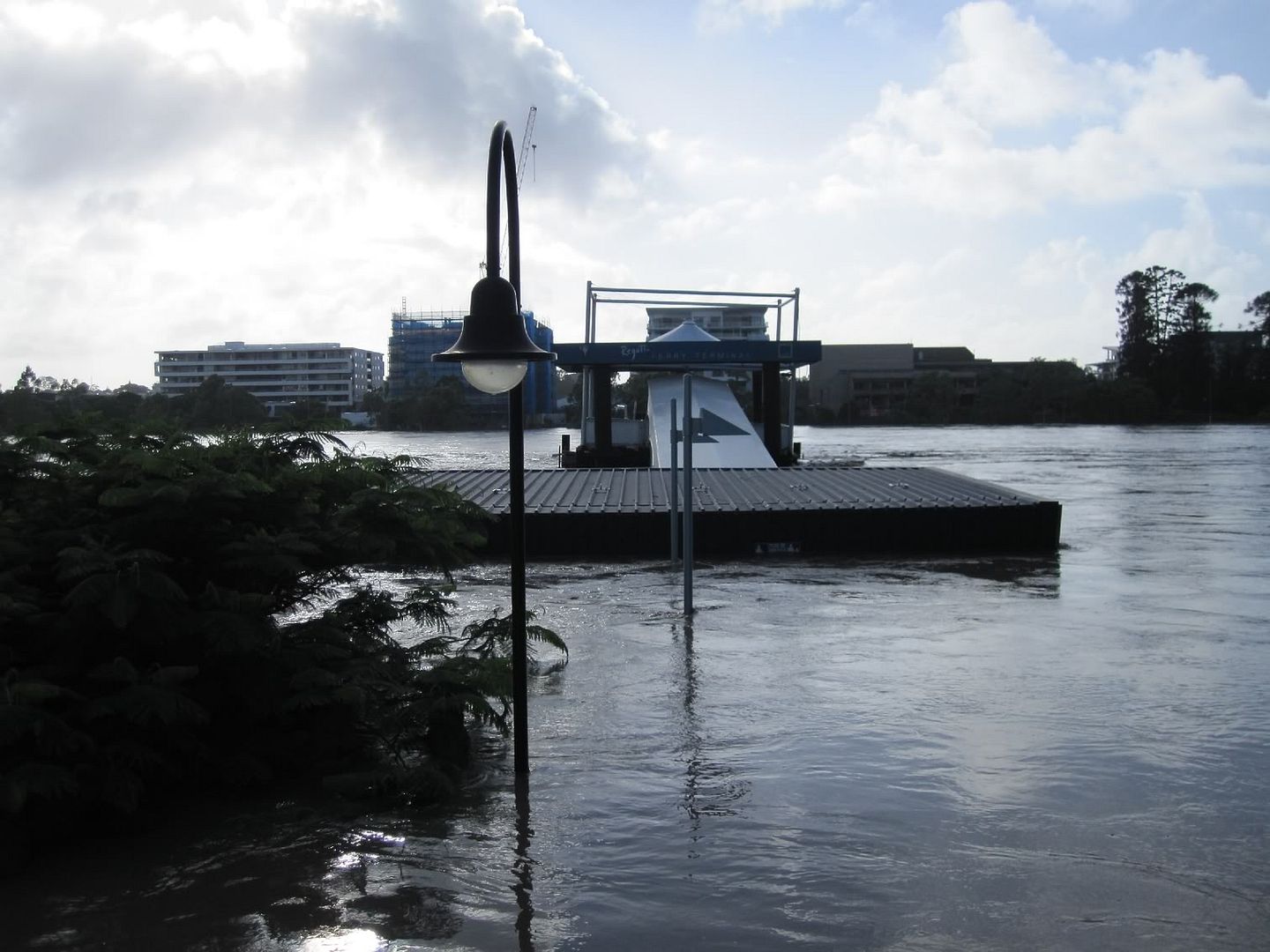
this is the toowong city cat terminal well under water. looking across the other side of the river it looks like there is some flooding also???? not sure. tomorrow water will be 2.5m+ higher.
that's another storey nearly on the buildings across the river. ![]()
Sausage, thought you would have appreciated 9's excellent coverage this morning, exact quote "The water is only due to subside 100mil in the next 12 hours, to give you some perspective a can of coke is 375mil"
absolute gold! last time I checked mm and ml were slightly different measurements.
Gee some of our media guru's need edumucation in terminology or what. I can only get ch7 where we are at the moment, but the old fool Koshi sees a yard of excavators, big and small (track type diggers) and then starts to broad brush all earthmoving machinery as "Bobcats" ![]() Somebody need to drag his stupid head to one side and edumacate the bloody goose!!! that a Bobcat is a brand name like Holden and Ford. One of his minders needs to show him that an original Bobcat is a small skid steer load. An excavator is a track type backhoe; a Backhoe is a rubber tyred tractor with back hoe attached, and so on.
Somebody need to drag his stupid head to one side and edumacate the bloody goose!!! that a Bobcat is a brand name like Holden and Ford. One of his minders needs to show him that an original Bobcat is a small skid steer load. An excavator is a track type backhoe; a Backhoe is a rubber tyred tractor with back hoe attached, and so on.![]()
Maybe I need to call Uncle Kerry and get him on side![]()
The devastation suffered by those affected, doesn’t need to be enhanced by the media fools looking stupid on national TV.
Hope all you guys are safe and well up there. ![]()