Ledge Point is at 31deg 06' 27.36" S
Lancelin pub is at a latitude 31deg 00' 53.43" S
A difference of 0deg 05' 33.93"
The subtraction is not easy, which is why after a bit of head scratching I suggested racing between even minutes - so we could do it using the raw tracks - position vs. time - with no real need to get into computer programming.
So the LOC winners cross two circles of latitude separated by 05' 33.93" in 30 minutes, that's 5minutes 23sec for each minute of latitude. (two different meanings for "minutes" confusing all right!)
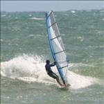
So a time of 5minutes 20 sec is what you'd aim for in latitude racing if you hoped to be on the winner's podium. That's what east coasters should be aware of when they go over. I thought I'd go reasonably well? Well I got to the pub in just over an hour, and even then I didn't round the last cray boat.
Sailing over one minute (1') of latitude you should be able to sail back without necessarily needing a car shuffle. If the idea goes further there could be bonus points for 2', 3' or 4' downwinders if you like.
For example if you were practicing from Ledge Point you'd sail down wind for about 10 minutes sail back and be looking for these sort of numbers in your downloaded track file
time .................................................position
12hr13min12 sec ............................31deg 06' 00.00".........115deg 22' 12.89"
12hr13min14 sec.............................31deg 05' 59.XX".........115deg 2X' XX.XX"
.etc
every 2 seconds etc etc
.etc
12hr18min36sec..............................31deg 05' 00.00'...........115deg XXXXXXXX
etc.
etc
(the Xs are not important in the calcs)
Now I'm hoping the lines of zeros in the position column stand out when you scan the track file and you can see that you covered 0deg 01' 00" of latitude from time 12hr13min12sec to 12hr18min36sec ie a time of 5min 24 seconds - you're on the pace.
Because the east and west coasts run roughly north south and the seabreeze come in at 45 degrees to coasts, there is a certain equivalence and the east and west coast playing fields are level.
Trouble with inviting the Vic and South Aussies to take part is that they'd have to use longitudes as the simple measure of downwind distance. And unlike latitudes, longitudes aren't parallel, the distance between them varies. That could be fixed with some clever programming though.
(btw there's only two "t"s in latitude)
Good to see some interest from WA