GPS Motion X

> 10 years ago
Reply
Register to post, see what you've read, and subscribe to topics.
PTWoody
PTWoody
VIC
3982 posts
VIC, 3982 posts
25 Jan 2010 9:31pm
Finally worked out how to output the data from this Motion X GPS iApp.

DJ, if you haven't sorted it for yourself, here's how I did it...

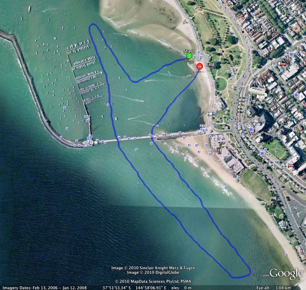
It's a pretty convoluted process because the native output format uses Google Maps instead of Google Earth, so to get the satellite image involves a bit of stuffing around, pulling a file into Google Earth program, then copying that image and turning it into a JPG in Photoshop. But the first thing you have to do immediately after finishing your GPS session is save your track inside the iPhone, then go to the library which is the page just before the iPod page. Click on tracks and open the track you just saved, rename it and then simply click on "Share Track Now". The program will take you through a set up the first time to nominate the email to send it to (you can send to up to 5 email addresses). After the first time you set this up, after that it automatically emails to your designated list when you hit Share Track Now. Then go to your mail program and open the email and you will find all the session details and links to the map as well as Google Earth instructions.

This data and imagery below is from a paddle I did this morning around the proposed Port Phillip Cup route. Travelling on a Starboard Blend 11'2". Not much wind but a little bit of current coming from the south, particularly outside the breakwater.


Port Phillip Cup practice Monday 25/1 uses MotionX-GPS on the iPhone 3G or 3GS and is sharing with you the following track:

Name: More Port Phillip practice
Date: 25/01/2010 8:11 am
Distance: 2.80 kilometers
Elapsed Time: 28:14.1
Avg Speed: 6.0 km/h
Max Speed: 7.7 km/h
Avg Pace: 10' 04" per km
Min Altitude: 10 m
Max Altitude: 29 m
Start Time: 2010-01-24T21:11:35Z
Start Location:
Latitude: 37.861741º S
Longitude: 144.970173º E
End Time: 2010-01-24T21:39:49Z
End Location:
Latitude: 37.862118º S
Longitude: 144.970636º E


BWDave
BWDave
VIC
239 posts
VIC, 239 posts
25 Jan 2010 10:06pm
Great info though I am not sure how you got a 19meter altitude difference. Big swell?
PTWoody
PTWoody
VIC
3982 posts
VIC, 3982 posts
25 Jan 2010 10:13pm
Curvature of the Earth?
Lfish
Lfish
402 posts
402 posts
25 Jan 2010 7:29pm
AAAhhhhh..........now I know why the Vics are a little....................mexican.....bloody big curvature of the earth down there
North
North
WA
104 posts
WA, 104 posts
25 Jan 2010 7:45pm
Hey PTWoody,

I've been playing around with MotionX as well. If you have a Facebook Profile there is a MotionX App you can upload. You can view the track and a graph of speed/pace of the journey and a few other gadgets

I'm a sucker for a gadget
PTWoody
PTWoody
VIC
3982 posts
VIC, 3982 posts
25 Jan 2010 11:02pm
Thanks North, I'll check out the Facebook app
DavidJohn
DavidJohn
VIC
17570 posts
VIC, 17570 posts
25 Jan 2010 11:35pm
Thanks for that Paul.. But my brain hurts now reading through your instructions..

DJ
PTWoody
PTWoody
VIC
3982 posts
VIC, 3982 posts
25 Jan 2010 11:40pm
Yes my career as a tech guide writer is over before it started.

I'll show you what I mean tomorrow.
Greenroom
Greenroom
WA
7608 posts
WA, 7608 posts
25 Jan 2010 9:33pm
DavidJohn said...

Thanks for that Paul.. But my brain hurts now reading through your instructions..

DJ

Im with you on that one DJ
Im using motionx as well but only for top speed in knots when windsurfing.
Something I found was that it only went to 26 knots. I am using the free version so that might be the problem?
Lobes
Lobes
885 posts
885 posts
25 Jan 2010 11:42pm
I also have the free version for the iPhone. I tried it out on the plane and I was getting 500 miles an hour.

PT very interesting I'll have to get you to show me tomorrow too
Please Register, or first...
Topics Subscribe Reply

Return To Classic site 😭
Or... let us know if a problem, so we can tweak! 😅