Ahoy Captains!
I've searched through the forum history looking for info on laptops on boats, but I can't seem to find an answer specific to my questions.
So I'm hoping someone on here can give me some advice.
I want to run a laptop down below, one which I can use as an everyday computer, emails, looking at boat porn and general computer usage. I also want the ability to "see where I am" on Google Earth for example, and perhaps also run Opencpn or similar on it. I would prefer if the mapping aspect could run without needing WIFI availability.
It would not be my primary source of GPS mapping, I have one in the cockpit for that.
So do I need a GPS enabled laptop, or use a puck?
Which brands would you recommend?
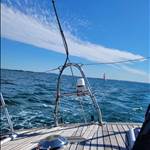
Am I asking the right questions?![]()
Any advice is much appreciated!
Cheers.
I have a Mini PC Beelink i3 5005U Dual Core 8GB DDR3L / 128GB SSD - Win 10 with 1 TB Ext HDD + monitor + Sirf 4 GPS.
There are probably some more "modern" ones on eBay by now but I've had this running for a few years for everyday "computering" with no trouble at all. Search eBay for Mini PC. Ali Express is probably your best bet for a Sirf 4 GPS.
It's not a laptop but I find it much better than a lappy. I have one as backup somewhere!!
I run OpenCPN, Memory Maps, Google Earth & some others using the GPS puck.

Laptops on boats and in the tropics used to die primarily from mould in the floppy drive and hard drive. With USB memory sticks and solid state drives, most those weaknesses are no longer an issue. I don't think Laptops have gps capability so you'd probably need a puck.
However, do you need a laptop? A lot of tablets will do everything you're wanting.
Select to expand quoteBushdog said..
Laptops on boats and in the tropics used to die primarily from mould in the floppy drive and hard drive. With USB memory sticks and solid state drives, most those weaknesses are no longer an issue. I don't think Laptops have gps capability so you'd probably need a puck.
However, do you need a laptop? A lot of tablets will do everything you're wanting.
Thanks Bushdog, my preference is for a laptop.
On my old yacht, I used an old windows laptop with a GPS puck before moving on to a mini PC with an SSD hard drive. These are basically a laptop without a screen. I used a 27 inch lcd TV as the monitor. What you need most with navigation is real estate, 20 inch screen is the minimum.

In my new boat I have a similar mini PC with a 20-inch monitor mounted in the portrait mode and the GPS and AIS come from the VHF radio. To go online I use my mobile plugged in with a USB line. The laptop used to draw about 4 amps and my current set up about the same. A modern lcd TV would draw less than the old-style Dell monitor but I had a few laying about.
If you choose a tablet make sure it's a Windows unit.

Hi,
Since you are going the nerd path of OpenCPN my suggestion is to simply use an NMEA2K interface and get the GPS directly from the boat network.
Most modern boats have more GPS than they need: Modern chartplotters and AIS will have one. Then most boats tend to have a standalone one (helo Furuno....). Many boats will have one within modern VHF, iridium go, starlight... GPSs are so cheap nowadays vendors just add then regardless..
If you really need one (I doubt you need) you can find a decent GPS USB dongle for less than 50AUD. Make sure at least on of your boata GPSs have an external antenna for better signal.
For connecting to the NMEA2K bus I recommend either an Yacht Devices or Actisense USB dongle.
If you prefer a bit more isolation, both brands also have WiFI. Another option in that front is HatLabs. The advantage (and disadvantage) of using WiFi is that you don't need to establish electrical connection between NMEA2K and the laptop.
With a fibreglass or timber yacht, it does not matter where the USB puck is situated. In the top photo, the SIRF4 chip puck is sitting on a shelf [magnetic base onto a galvanised washer]. Out on the deck, it works just the same. The GPS receiver in the bottom photo is in the VHF on the chart table. The laptop is running Seaclear [free], but I now use OpenCPN because it is simple to use and free.
VHF radio GPS/AIS to the computer will need one of these, I can not remember the cost but cheap.

I just installed an openplotter, opencpn, signalk setup on the boat on the weekend.
I wanted something small and low power so i could keep in onboard and running all the time so I can add remote monitoring of anything interesting (anchor watch, bilge alarm, beer temp, etc)
I went with:
- Raspberry pi 4
- waveshare 4g + GPS "hat"
core-electronics.com.au/waveshare-4g-hat-for-raspberry-pi-lte-cat-4-4g-3g-2g-gnss.html
- a victron "vedirect usb cable" to hook into the solar mppt controller
no screen yet, but those portable 16" monitors look good for ~$150 and work of existing usbc power
the 4g/gps hat plugs right into the raspberry pi, so its a compact setup that is probably lower power than having another separate device for a 4g router. the pi does its own wifi for anything else aboard.
all up seemed to be drawing about 500ma, eyeballed from the shunt with the above on/off
Select to expand quoteSailorDave said..
I just installed an openplotter, opencpn, signalk setup on the boat on the weekend.
I wanted something small and low power so i could keep in onboard and running all the time so I can add remote monitoring of anything interesting (anchor watch, bilge alarm, beer temp, etc)
I went with:
- Raspberry pi 4
- waveshare 4g + GPS "hat"
core-electronics.com.au/waveshare-4g-hat-for-raspberry-pi-lte-cat-4-4g-3g-2g-gnss.html
- a victron "vedirect usb cable" to hook into the solar mppt controller
no screen yet, but those portable 16" monitors look good for ~$150 and work of existing usbc power
the 4g/gps hat plugs right into the raspberry pi, so its a compact setup that is probably lower power than having another separate device for a 4g router. the pi does its own wifi for anything else aboard.
all up seemed to be drawing about 500ma, eyeballed from the shunt with the above on/off
Yep, the Raspberry Pi is good gear.
I'm running a Pi4 with Openplotter, Signal K & OpenCPN etc. which monitors everything 24/7!! All temperatures (fridge, freezer engine, alternator etc.) battery condition, any movement in the cockpit it notifies me & sends pics, if the boat moves from it's mooring it lets me know, I can turn pump relays on/off from home or phone, it is integrated with my Raymarine plotter, it automatically fills in a logbook, etc, etc etc!!
It can be seen in my earlier pic just to the left of the Mini PC - the 3 blue "boxes" are relays.
I have a new Pi5, which I'm waiting on a special HAT before I install, which will upgrade everything for the better!!
This is just some of the info from Signal K:


which can be used for things like this:


I ended up buying a laptop after all.
I've been looking into OpenCPN charts for Australia as a back up charting system, but it looks like they don't supply it for free.
Those of you who have Open CPN, did you end up paying for the Australian charts from O Charts?

Select to expand quoteNowandZen said..
I ended up buying a laptop after all.
I've been looking into OpenCPN charts for Australia as a back up charting system, but it looks like they don't supply it for free.
Those of you who have Open CPN, did you end up paying for the Australian charts from O Charts?
Yes, bought the charts from O-charts. Good value. Interestingly, when I updated to the latest version there was no detail for the Gippsland Lakes west of Fraser Island. Still trying to resolve the issue with O-charts support. Anyone else have the same problem?
Kinora
Select to expand quoteKinora said..NowandZen said..
I ended up buying a laptop after all.
I've been looking into OpenCPN charts for Australia as a back up charting system, but it looks like they don't supply it for free.
Those of you who have Open CPN, did you end up paying for the Australian charts from O Charts?
Yes, bought the charts from O-charts. Good value. Interestingly, when I updated to the latest version there was no detail for the Gippsland Lakes west of Fraser Island. Still trying to resolve the issue with O-charts support. Anyone else have the same problem?
Kinora
I have no detail from Russell Isl to Runaway Bay in Southern Moreton Bay and that was on two different laptops.
Select to expand quotecammd said..Kinora said..NowandZen said..
I ended up buying a laptop after all.
I've been looking into OpenCPN charts for Australia as a back up charting system, but it looks like they don't supply it for free.
Those of you who have Open CPN, did you end up paying for the Australian charts from O Charts?
Yes, bought the charts from O-charts. Good value. Interestingly, when I updated to the latest version there was no detail for the Gippsland Lakes west of Fraser Island. Still trying to resolve the issue with O-charts support. Anyone else have the same problem?
Kinora
I have no detail from Russell Isl to Runaway Bay in Southern Moreton Bay and that was on two different laptops.
I've just checked that area on my tablet and get the same result. No detail from the northern part of Russell Island to the northern edge of Crab Island. I've been through there. Not somewhere where you want your navigation aids to be unreliable.
K.
These bad boys have got plotter written all over them: www.officeworks.com.au/shop/officeworks/p/blaupunkt-15-6-fhd-touch-screen-portable-monitor-bp15pmt60
they even do a 4K version.
edit - yes they are screen only but.
1. Perfect for raspberry pi
2. 5v power usb c
3. vesa mount
4. touch screen
Select to expand quoteKinora said..cammd said..Kinora said..NowandZen said..
I ended up buying a laptop after all.
I've been looking into OpenCPN charts for Australia as a back up charting system, but it looks like they don't supply it for free.
Those of you who have Open CPN, did you end up paying for the Australian charts from O Charts?
Yes, bought the charts from O-charts. Good value. Interestingly, when I updated to the latest version there was no detail for the Gippsland Lakes west of Fraser Island. Still trying to resolve the issue with O-charts support. Anyone else have the same problem?
Kinora
I have no detail from Russell Isl to Runaway Bay in Southern Moreton Bay and that was on two different laptops.
I've just checked that area on my tablet and get the same result. No detail from the northern part of Russell Island to the northern edge of Crab Island. I've been through there. Not somewhere where you want your navigation aids to be unreliable.
K.
I just sent O-Charts an email reporting the problem, have to wait an see if it gets sorted
The reply
oeSENC charts are 100% identical to the official ones as issued by the
Australian Hydrographic Service. We are not chart editors, so we do not
add to or remove from anything from the charts and distribute thecharts
as we receive them from AHS. Unfotunately, AHS, like other Hydrographic
Offices are focused mostly on commercial navigation and forget about
leisure sailors, so some areas which are not of interest for commercial
navigation are just not covered.
As far as we know, there are some Queensland Government publications
like the Beacon to Beacon Guide of Southern Moreton Bay (in PDF) from
MSQ
(www.publications.qld.gov.au/dataset/moreton-bay-boating-maps),
if that helps.
Best regards
Asking the same question from a different perspective.
What's the best computer/laptop to get the least power consumption running off 12V supply?
The primary use would be at anchor, with a really big hard drive holding movies and 1000's of songs when out of range of phone signal. WIFI/bluetooth to tablet display or portable boom box in the cockpit. Some passage planning, books and logs.
Select to expand quoteEastCoastSail said..
Asking the same question from a different perspective.
What's the best computer/laptop to get the least power consumption running off 12V supply?
The primary use would be at anchor, with a really big hard drive holding movies and 1000's of songs when out of range of phone signal. WIFI/bluetooth to tablet display or portable boom box in the cockpit. Some passage planning, books and logs.
This isn't necessarily a "best" but I would contemplate using a raspberry pi and one of those screens I linked from office works - the usb c powered ones.
You'll get better mileage sticking to 1080 movies. Most of your power consumption (outside the screen) comes from decompressing the video, and when you watch 4k it has a **** load of work to do.
ive ordered a 12v to 5v dual usb adapter from eBay. I'll post here when I get it and try it out.
Make sure the hard drive is SSD so it uses less power than one with a motor.
don't forget your raspberry pi can double as plotter and show all your instruments too.
Sorry, tried to edit but couldn't.
I looked at the tablet computers on sale the other day. For the money they're hard to beat and they should be competing hard with each other on battery life.
The trouble with either the android or the windows tablets is that there's an hour or two of work on getting all the bloatware and spyware off them to make them usable - remember anything that's running or communicating is sucking juice.
The trouble with tablets is they usually don't have enough USB ports. I have a windows 11 inch tablet I use for engine tuning that has a clip-on keyboard but is mostly a touch screen especially when not using the keyboard. The slightest hint of moisture and a touch screen is useless.
I personally think the tiny ThinkCentre units are the way to go. They are fast and excellent on power.
www.ebay.com.au/itm/266498211191?itmmeta=01HW3X5H8PK6H61V04XD6455CE&hash=item3e0c87fd77:g:LKQAAOSwREtlWpfa&itmprp=enc%3AAQAJAAAAwNJzXHuqG8g0bpFycwYnwj%2BZmiqcpmZXKWiCQcuO7FQt%2FbJ9UJfRWQW1DjCRlRl1UUissxlPvIOern75F8TvmEIprZDUdBo5VNv85Df6haz%2BahrVb%2BR62pWoBzQQ%2FbDLPJnUun0sDV9PXqyRwL9CTsVAuc4deJgyq6jSZePVOPsSYB%2FYr%2BlbnNH7Pv6i4EGlK69qXa3a69utu2BHstRe3thqGxA%2F0K%2BhreE0yVqvCII3%2F67cDjT7fGdOkAjr9MDltw%3D%3D%7Ctkp%3ABlBMULaUlv3gYw
For a monitor the 12v TV's are excellent and low on power consumption. This one is listed as less than 1w and I am sceptical of that. In my last boat, I had that combination and the consumption was less than a 13 in laptop.
www.ebay.com.au/itm/283420562845?itmmeta=01HW3XGXGJY23M48S8J3PFPJP5&hash=item41fd2e959d:g:CToAAOSw~eFkf-LW&itmprp=enc%3AAQAJAAAAwBA%2****lyPE832rFmglBjcFz1TvJc5SeEQPGaQcKJ8Py7YEAHkhOVL%2Bu62Eoa7E4D%2FkbvX%2B7n2Uc5zo5Blm0e55YvPxeo%2FHMSTF%2Fp3iKwlIP1sZkyt05bIyh%2BefeQxH8v%2FvALOCkkcq%2FqPf2W5HS3AfUd6m%2FnpPNS48w2XRqSfAXcCPXUoHWJxhD2YWALvTSAkpkPABkTQyXFhSsuiJHPi%2BUL%2F7FGZRd1SY%2FbRzWPeG1rd9uMmmwpNhxwgyOH9pwl%2Fg%3D%3D%7Ctkp%3ABlBMULLYw_3gYw
Select to expand quotecammd said..
The reply
oeSENC charts are 100% identical to the official ones as issued by the
Australian Hydrographic Service. We are not chart editors, so we do not
add to or remove from anything from the charts and distribute thecharts
as we receive them from AHS. Unfotunately, AHS, like other Hydrographic
Offices are focused mostly on commercial navigation and forget about
leisure sailors, so some areas which are not of interest for commercial
navigation are just not covered.
As far as we know, there are some Queensland Government publications
like the Beacon to Beacon Guide of Southern Moreton Bay (in PDF) from
MSQ
(www.publications.qld.gov.au/dataset/moreton-bay-boating-maps),
if that helps.
Best regards
Hmmm, interesting reply and not very helpful. In the case of the missing details for Gippsland Lakes, it was there in a previous edition of O-charts. I guess the next thing is to follow up with the Australian Hydrographic Service to make sure the relevant charts are still available. I'll try and find time to do this in the next week or 2, unless someone beats me to it.
K.
To my understanding all of the AHO charts that were available are still available in electronic form, with the exception of areas that had duel scale they have been rationalised. I don't want to sound like I'm banging on about it but the official AUS ENC is straight from the source and cheap 2 cells gets all of NSW and a generous bit of SE QLD. $80ish per cell. Updated in real time ( no need to consult notice to mariners ) while in no the subscription period, but you still have the Electronic Navigation Chart on your device after the subscription lapses, alas with no updates. Talk to boat books, I've found them excellent at providing information
Select to expand quoteRamona said..
The trouble with tablets is
Thank you for that, informative and pointed me in a new direction to explore. The main issue I perceive I have is I have one 3000W inverter, analogue battery voltage gauges so I don't really know the consumption of my inverter to power the 240V devices. I also perceive that if I have devices that run off 12V or or USB overall power consumption would be less?