ezza said...Advice please WA wind gurus?

Hi Ezza,
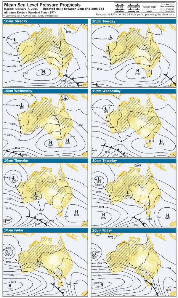
You need only look at the Synoptic Situation on Friday and you'll see a large high down in the bight moving VERY slowly eastward. The winds travel anti-clockwise around the center of the high and also, due to the higher pressure than the surrounding air pressure then as it is heavier, it falls and spreads out thus adding a slightly outward vector to the already anti clockwise moving wind.
The closer the isobars, the greater pressure differential and thus the faster the air movement or in laymans terms, the stronger the wind.
Notice also the low pressure above the state off the coast of Exmouth, the rules of wind direction are opposite the High pressure, so between the high and the low, they are both funneling offshore wind into the Indian Ocean. The dashed line reaching down the coast is a trough. Troughs are generally created when seabreezes oppose the wind directed by the "system" air pressures. They cancel each other out and create an area of hot offshore winds in the morning stalemating the seabreeze allowing the land to get quite hot. Winds sometimes can go southerly for a brief period before switching back offshore again in the early evening.
Unless the high in the bight gets moving a little quicker, the prognosis for wind over the KS weekend isn't good. Hot, dry and gusty southeasterly winds with a slight chance of a southerly burst for an hour or two on Sunday.
But hey, that's just my interpretation of the Synoptics.
Cheers,
DM

 Plenty of kiting crew to catch up with and share the stoke.
 you just need a mate with a boat
 Any local spearo's know
 and certainly not wanting to put the wammy on KS, as a Sponsor and demoer, I have more at stake than the average punter, I want wind!