East vs. West. Seabreeze Lattitude racing
Broad reaching off the coast of NSW in the first seabreeze of the season on tuesday had me thinking of my one attempt at the Ledge to Lancelin Ocean Classic a few years ago. What a great event, pity it's only on once a year and on the wrong coast. There should be more of it. Can we use the GPS to generate more interest in downwinders?
So I'm throwing down a challenge for the coming summer. It's called Latitude racing. East vs. West. Sou'wester vs. Nor'easter. Our seabreeze is as good as your seabreeze. (I'm hoping my NSW compatriots will back me on this one)
Here's the first draft of the rules, feel free to suggest variations.
Race downwind between even minutes of lattitude, ie a Nautical mile, you must put in 3 gybes so you're not tempted to go too far off shore. Fastest transit times score most points for the series. Groups of 3 racing racing as a pack score safety bonus points. It should be pretty easy to scan your tracks for the even minute of lattitude crossings and hence transit times.
I've checked google earth. There are plenty of good courses available on the east coast. Here's a few.
Pittwater : 33deg 43' S to 33deg 44' S
Botany Bay : 33deg 57' S to 33deg 58' S
Sandon Point : 34deg 20' S to 34deg 21' S
Gerroa : 34deg 37' S to 34 38' S
Plenty on the West coast - it's so straight no treacherous headlands to worry about
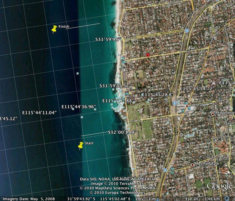
ie Cottesloe 32deg 00' S to 31deg 59' S
Unfortunately I can't get my GPS to show Lat / Long in large format which would make it easy to see where you're at out on the water. But I think you'd soon become familiar with your local course and that wouldn't be a problem.
Anybody up for it?
As an example the courses at Pittwater and Cottesloe